
Navigating Your FlytBase Platform
Explore the FlytBase platform interface, including the sidebar navigation, top bar, map toolbar, and all modules for flight operations, planning, monitoring, and management.
The FlytBase platform organizes all drone operation tools in a sidebar navigation panel on the left side of the screen. The sidebar is divided into functional categories - Flight Center, Verkos AI, Flinks and Flows, Flex Factory, Planning, Zones, Logs, and Management - each grouping related modules together. This page provides an overview of every module available in the platform and how to access it.
Flight Center
The Flight Center is the operational hub of the platform, providing real-time access to drone control, situational awareness, and live video feeds.
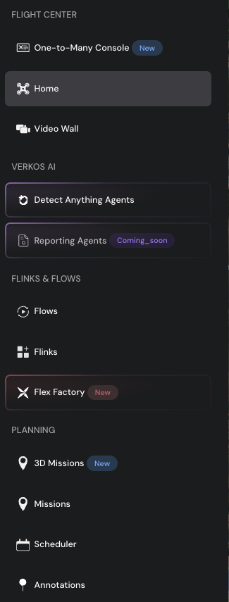
One-to-Many Console
The One-to-Many Console allows operators to monitor and control multiple drones simultaneously from a single interface. Use this console to manage fleet-wide operations, view live telemetry from all connected drones, and issue commands across the fleet.
Home
The Home dashboard provides a centralized overview of the platform. It displays the interactive map, the number of registered devices, active sites, and key operational metrics at a glance.
Video Wall
The Video Wall displays live video feeds from multiple drones in configurable grid layouts. Select from grid formats such as 2x2, 3x3, or 4x3 to monitor simultaneous video feeds. This module functions as a Remote Operations Center (ROC) interface for multi-drone surveillance and monitoring.
Verkos AI
Verkos AI provides intelligent detection and reporting capabilities powered by artificial intelligence.
Detect Anything Agents
Detect Anything Agents are AI-powered detection modules that analyze drone video feeds in real time. These agents can identify objects, anomalies, and events across a wide range of use cases. Refer to the Verkos AI documentation for the full list of supported detection capabilities.
Reporting Agents
Reporting Agents automate the generation of structured reports from drone operations and detection results. This module is coming soon.
Reporting Agents is currently under development and will be available in an upcoming release.
Flinks and Flows
Flinks and Flows enable integration with external systems and automated drone workflows triggered by events.
Flows
Flows allow operators to define automated actions that drones perform in response to external triggers. For example, when an alarm is triggered by an integrated security system, a Flow can command a drone to fly to a specific location, perform a mission, or execute a predefined action sequence. Use Flows to connect events to drone responses.
Flinks
Flinks are integration connectors that link the FlytBase platform with external systems. Use Flinks to integrate alarm systems, Real-Time Streaming Protocol (RTSP) video feeds, and other third-party data sources with the platform.
Flex Factory
Flex Factory is a collection of specialized applications that extend the capabilities of the core FlytBase platform. Instead of building every use case directly into the platform, Flex Factory provides purpose-built apps - such as AI-based analysis, forensic search, automated workflows, and other operational modules - that can be activated depending on specific operational requirements.
Flex Factory apps are modular add-ons. Contact FlytBase for information on available apps and activation.
Planning
The Planning section contains tools for mission creation, scheduling, and spatial annotation.
3D Missions
3D Missions provide a three-dimensional visualization of mission plans. Create grid missions, waypoint missions, and other mission types with full 3D visualization of the flight path, altitude, and terrain context before executing the mission.
Missions (2D)
The Missions module offers a two-dimensional mission planning interface with the same core functionality as 3D Missions. This module provides a simpler view for standard mission planning workflows.
The 2D Missions module is scheduled for deprecation. Use 3D Missions for all new mission planning.
Scheduler
The Scheduler is a calendar-based tool for planning drone missions in advance. Schedule missions to run at specific times, set up recurring schedules for periodic operations, or plan future missions across the fleet.
Annotations
Annotations allow operators to add spatial markers to the map. Import annotation sets or create individual annotations in multiple formats - including points, lines, and polygonal shapes - to mark areas of interest, inspection targets, or operational boundaries.
Zones
Zones define geographic boundaries that govern drone flight behavior.
Geofences
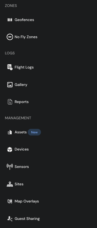
Geofences are virtual boundaries drawn on the map that define the operational area for drone flights. Configure geofences to restrict drone movement to a designated zone during missions.
No-Fly Zones
No-Fly Zones are restricted areas where drone flight is prohibited. Define No-Fly Zones on the map to prevent drones from entering restricted airspace or sensitive locations.
Logs
The Logs section stores all post-flight data, captured media, and operational reports.
Flight Logs
Flight Logs capture all flight data and assign each flight a unique flight ID for tracking. View details such as the pilot who operated the drone, the time of the flight, and the mission that was performed. Flight Logs also include a playback feature that animates the drone's flight path on the map, allowing operators to review the complete mission trajectory.
Gallery
The Gallery stores all images and videos captured during drone flights. Browse, view, and download media assets from completed missions.
Reports
Reports allow operators to generate consolidated reports from one or more flights. Create post-flight reports that compile flight data, captured media, and operational metrics for review and documentation.
Management
The Management section provides tools for configuring devices, sensors, sites, and access controls.
Assets
Assets allow operators to organize drone operations around physical infrastructure - such as mine heaps, pipelines, substations, tanks, road segments, or other site assets. Structure assets and sub-assets in a hierarchy, associate drone missions and inspection workflows with each asset, and build a centralized operational view rather than treating every flight as an isolated mission.
Devices
The Devices module displays all registered drones and docking stations along with their critical information. Add, configure, and maintain devices, access remote diagnostics, and view device health status.
Sensors
The Sensors module shows all sensors integrated with the platform, including detect-and-avoid sensors, air data sensors, and other connected hardware.
Sites
Sites represent physical locations where drone operations take place. Create and manage sites, assign devices and members to specific sites, and configure site-level access controls based on operational requirements.
Map Overlays
Map Overlays allow operators to import and display additional geographic data layers on the platform map. Upload point cloud data, terrain models, or 2D overlay layers to visualize supplementary information on top of the base map at operational sites.
Guest Sharing Links
Guest Sharing Links provide temporary access to the platform for external users. Generate shareable links that allow guests to view specific operations, video feeds, or data without requiring a full FlytBase account.
Top Bar
The top bar at the top of the screen provides quick access to platform-wide tools and account settings. From left to right, the icons are:

- Flex Factory - access the Flex Factory app launcher and browse available apps
- Help (?) - report an issue, access documentation, or navigate to the tickets section
- VVM Usage (graph icon) - view Video Viewer Minutes (VVM) usage and consumption data
- Notifications (bell icon) - receive notifications about activity and events happening inside the platform
- Settings (gear icon) - configure flight parameters, device settings, and platform preferences
- Releases (gift icon) - view upcoming and recent platform releases and feature updates
- Profile (profile icon) - view profile information, switch organizations, and manage account settings
Map Toolbar
The right side of the map view displays a vertical toolbar with quick-access buttons for third-party integrations and map controls.
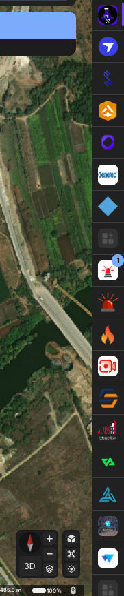
The toolbar includes:
- 3D toggle - switch between 2D and 3D map views
- Compass - orient the map to north
- Zoom controls - adjust the map zoom level
- App integrations - access connected third-party services and tools directly from the map view
Was this helpful?